
AL
The AL St Albans Postcode Area
The AL postcode area is a group of postcode districts in the southeastern part of England, covering the city of St Albans and the surrounding area. It is a beautiful and historic region of the country, with a rich cultural heritage, stunning architecture, and picturesque countryside.
St Albans, the main city in the AL postcode area, is a thriving city with a rich history that dates back to Roman times. The city is home to the St Albans Cathedral, which is one of the most impressive medieval cathedrals in England. It is also a vibrant city with a range of cultural and historical attractions, such as the Verulamium Museum, the Alban Arena, and the St Albans Museum and Gallery.
The AL postcode area includes a range of urban, suburban, and rural areas, from the bustling city center of St Albans to the charming villages of Hertfordshire. It stretches from the River Colne to the Chiltern Hills and includes several towns and villages such as Harpenden, Radlett, and Borehamwood.
The area is known for its beautiful countryside and outdoor recreational opportunities. The Chiltern Hills are a short drive from St Albans and offer some of the most stunning countryside landscapes in the UK, with hiking, cycling, and horse riding opportunities. The area is also home to many beautiful parks and gardens, such as Verulamium Park, which is famous for its lakes and wildlife.
The economy of the AL postcode area is diverse, with several major employers, including AECOM, Imagination Technologies, and the University of Hertfordshire. The area has a strong technology sector, with many start-ups and tech companies located in the business parks around St Albans. The area also has a significant retail sector, with many shopping centers such as The Maltings and Christopher Place.
The AL postcode area has a rich history, dating back to Roman times. The city of St Albans was an important Roman settlement, and the ruins of the Roman Theatre and Verulamium are a testament to the city's past glory. There are also many historic sites related to the Norman Conquest, including St Albans Castle and the Bayeux Tapestry.
In terms of transportation, the AL postcode area is well-connected by road, rail, and air. The M1 motorway runs through the heart of the area, providing connections to London and the Midlands. St Albans Station is a major railway hub, with direct trains to London, Brighton, and many other major UK cities. The area is also served by several airports, including London Luton and Heathrow.
In conclusion, the AL postcode area is a beautiful and historic region of the country, with a rich cultural heritage, stunning architecture, and picturesque countryside. Whether you're looking to explore historic sites, enjoy outdoor activities, or experience the city's vibrant atmosphere, the AL postcode area has something for everyone.
AL is a postcode area located in England's Eastern Region.The Postcode Area covers the landscape areas of Chilterns and Northern Thames Basin
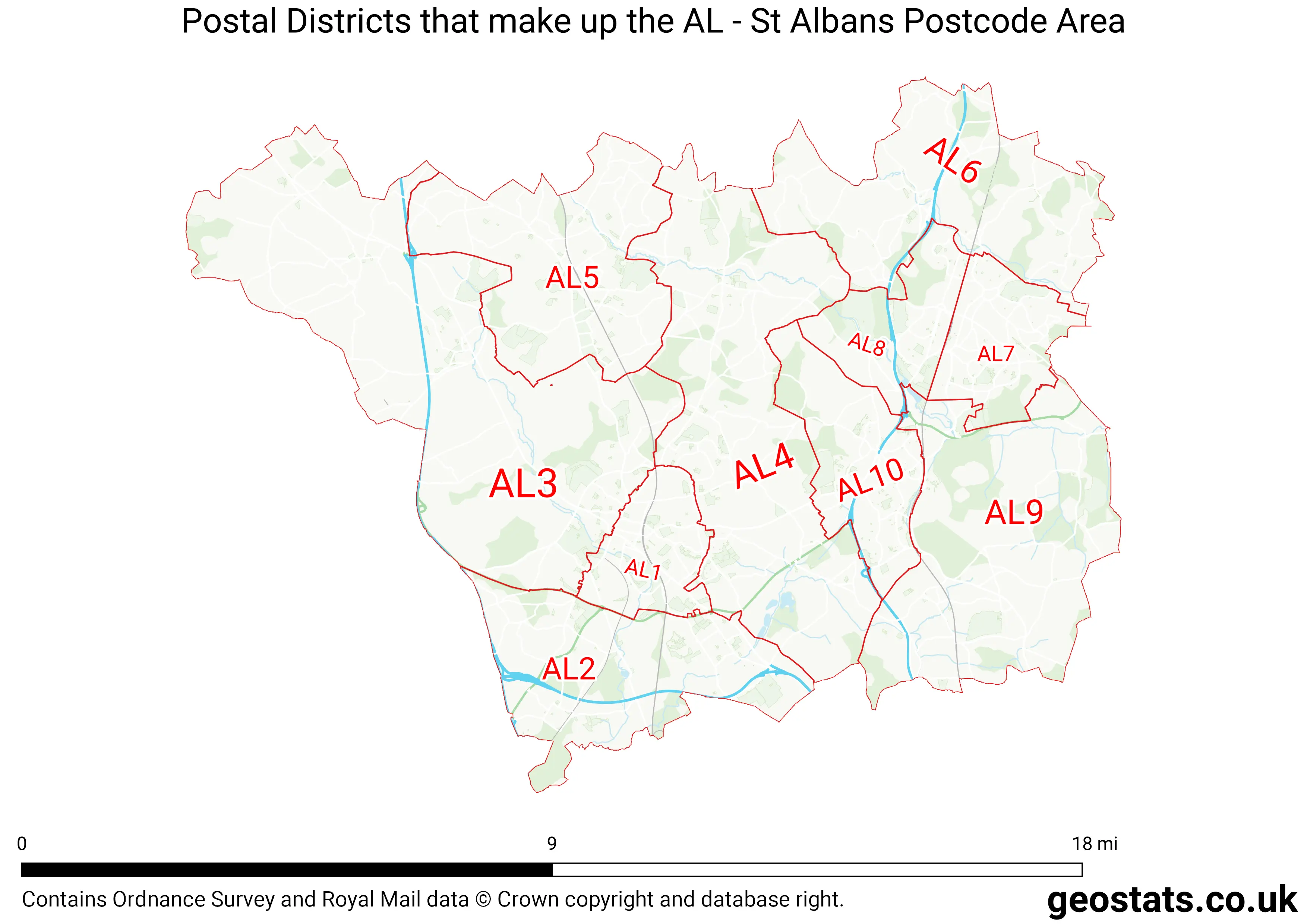
Neighbouring postcode areas include SG, LU, EN, HP, AL and WD
The AL Postcode Area consists of 10 postcode districts numbered from 1 to 10 and 39 postcode sectors.
This postcode area is named after the letters AL found in St Albans
There are around 148,131 properties in the AL Postcode Area
The are about 7,788 postcodes in the AL area.
AL has an area of 298,157,749 metres squared, which makes it 87 times bigger than the smallest postcode area (WC West Central London) and 54 times smaller than the largest postcode area (IV Inverness) . It has a perimeter of 136,667 metres.
Map of the AL Postcode
List of Cities in the AL Area
- St Albans
List of Towns in the AL Area
- Harpenden
- Hatfield
- Welwyn Garden City
List of Post Towns for the AL Sector
- HARPENDEN Hertfordshire
- HATFIELD Hertfordshire
- ST. ALBANS Hertfordshire
- WELWYN Hertfordshire
- WELWYN GARDEN CITY Hertfordshire